Un peu de difficulté à maintenir ce site à jour...je l'avoue :)
Probablement que si je passais moins de temps à travailler sur un logiciel puis un autre, tout en préparant des cours, je parviendrais à avoir un fil d'articles plus régulier, enfin, j'envisage aussi de recentrer ce site sur sa 'vocation' de départ, soit le limiter aux applications de génie environnemental, municipal et travaux de terrains, donc surtout les logiciels comme Civil 3D, Autocad Map, Storm and Sewers et Infra 360, avec quelques autres applications qui pourraient venir s'y ajouter, des logiciels traitant l'information de sondages...éventuellement
Quant aux autres logiciels, Revit, 3D Studio et autres logiciels qui sont plus adaptés au dessin de pièces ou de bâtiments, soit que je ferai un nouveau site ou je les transférerai sur mon site, plus artistique, je verrai cela plus tard
Well can't say that this site is updated too often, mostly because I am spending quite a bit of time working and learning other softwares, writing a course and a few other things.
So I intent to bring back this site to his original purpose, mainly dealing with applications for environmental and civil (terrain) works, ie using Civil 3D, Autocad Map, Infra 360, Storm and Sewers and others things more related to soil investigation, borings and visualisation software, eventually...as for the others applications more related to general drafting or architecture, I will move them either to my more artistic site or a new one, don't know yet.
Link to my other site / Le lien vers mon autre site
JMR-ARTech
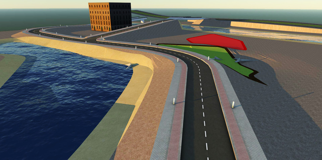
Je vais tout de même montrer une illustration faite dans Infra 360, très préliminaire, ce logiciel permet de faire un design ou avant-projet, qu'on peut exporter par la suite vers Civil 3D par exemple, où l'on peut faire un design plus détaillé, comme mentionné à ce point c'est plutôt sommaire, je me suis tout simplement amusé...
I will at least show a pic of a preliminary, very preliminary design made in Infra 360, this design can then be exported to Civil 3D to do a proper design, I still have to work on this, right now it was more like just playing and fooling around with it
Une illustration faite dans Infra 360, très préliminaire, ce logiciel permet de faire un design ou avant-projet, qu'on peut exporter par la suite vers Civil 3D par exemple, où l'on peut faire un design plus détaillé, comme mentionné à ce point c'est plutôt sommaire, je me suis tout simplement amusé...
Le logiciel vient avec trois modules : routes, ponts et aménagements rivières, lagunes.
A ce point-ci je n'ai fait qu'insérer quelques aires de développements tout en modifiant les élévations, importé un bâtiment et placé un viaduc, qui devra être refait, comme mentionné bien sommaire à ce point-ci, éventuellement je montrerai l'exportation vers Civil 3D, le redesign et la réimportation.
A pic of a preliminary, very preliminary design made in Infra 360, this design can then be exported to Civil 3D to do a proper design, I still have to work on this, right now it was more like just playing and fooling around with it, placing a few things, Actually this version has three modules : roads, bridges and river works, You place some areas assigning it some future uses, you can import as I did a building and build some overpass or bridges, I've also placed some culverts and modified elevation of different instances, eventually I will show more detailed operations, export to Civil 3D to refine the design and take it back here for final presentation, at this point though I am more or less just playing with it...
Probablement que si je passais moins de temps à travailler sur un logiciel puis un autre, tout en préparant des cours, je parviendrais à avoir un fil d'articles plus régulier, enfin, j'envisage aussi de recentrer ce site sur sa 'vocation' de départ, soit le limiter aux applications de génie environnemental, municipal et travaux de terrains, donc surtout les logiciels comme Civil 3D, Autocad Map, Storm and Sewers et Infra 360, avec quelques autres applications qui pourraient venir s'y ajouter, des logiciels traitant l'information de sondages...éventuellement
Quant aux autres logiciels, Revit, 3D Studio et autres logiciels qui sont plus adaptés au dessin de pièces ou de bâtiments, soit que je ferai un nouveau site ou je les transférerai sur mon site, plus artistique, je verrai cela plus tard
Well can't say that this site is updated too often, mostly because I am spending quite a bit of time working and learning other softwares, writing a course and a few other things.
So I intent to bring back this site to his original purpose, mainly dealing with applications for environmental and civil (terrain) works, ie using Civil 3D, Autocad Map, Infra 360, Storm and Sewers and others things more related to soil investigation, borings and visualisation software, eventually...as for the others applications more related to general drafting or architecture, I will move them either to my more artistic site or a new one, don't know yet.
Link to my other site / Le lien vers mon autre site
JMR-ARTech
Je vais tout de même montrer une illustration faite dans Infra 360, très préliminaire, ce logiciel permet de faire un design ou avant-projet, qu'on peut exporter par la suite vers Civil 3D par exemple, où l'on peut faire un design plus détaillé, comme mentionné à ce point c'est plutôt sommaire, je me suis tout simplement amusé...
I will at least show a pic of a preliminary, very preliminary design made in Infra 360, this design can then be exported to Civil 3D to do a proper design, I still have to work on this, right now it was more like just playing and fooling around with it
Une illustration faite dans Infra 360, très préliminaire, ce logiciel permet de faire un design ou avant-projet, qu'on peut exporter par la suite vers Civil 3D par exemple, où l'on peut faire un design plus détaillé, comme mentionné à ce point c'est plutôt sommaire, je me suis tout simplement amusé...
Le logiciel vient avec trois modules : routes, ponts et aménagements rivières, lagunes.
A ce point-ci je n'ai fait qu'insérer quelques aires de développements tout en modifiant les élévations, importé un bâtiment et placé un viaduc, qui devra être refait, comme mentionné bien sommaire à ce point-ci, éventuellement je montrerai l'exportation vers Civil 3D, le redesign et la réimportation.
A pic of a preliminary, very preliminary design made in Infra 360, this design can then be exported to Civil 3D to do a proper design, I still have to work on this, right now it was more like just playing and fooling around with it, placing a few things, Actually this version has three modules : roads, bridges and river works, You place some areas assigning it some future uses, you can import as I did a building and build some overpass or bridges, I've also placed some culverts and modified elevation of different instances, eventually I will show more detailed operations, export to Civil 3D to refine the design and take it back here for final presentation, at this point though I am more or less just playing with it...
 Flux RSS
